Despite this breakage, the crew is in good spirits with sunny skies and temperatures in the low 70s.
Friday, December 30, 2011
Sophia Turns Back to Cape Verde
We (the land based crew) just received word from the Sophianauts via the satellite phone that they are heading to the Cape Verde Islands. The windvane self-steering has received damaged and is inoperable. Sophia is presently about 350 miles N/NW of the Cape Verdes, so will alter course to land there and repair the windvane. The winds are currently around 25 knots with 9-12 foot seas, so it will be a tiring 3+ days steering by hand to get to the Cape Verdes. Certainly a good decision, rather than continuing on 2000 miles without an operable windvane.

Friday, December 23, 2011
Sophia Leaves The Canaries
As of 4:30 am PST Sophia disembarked on her longest crossing to date from Las Palmas to Saint Lucia. The weather report was for 10-15 knots from the Northeast. The crew - Joan, Jeff, Phil, and Chris. Track them on Spot.
Wednesday, December 21, 2011
Madeira to the Canaries
Sophia has set out again on her way to the Canaries, this time with Phil as skipper and Jeffrey and Christine as crew. The Three Amigos! They headed out on Friday (12/16) and arrived in Las Palmas on Sunday (12/18). It was a quick crossing -- just under 48 hours -- and according to Christine the first 30 hours were quite rough.
Joan joined the other Sophianauts on Tuesday in the Canaries, and now they are the Four Musketeers! They are preparing to head out for St. Lucia in the Caribbean in a couple days. You can watch their progress -- nearly 3000 miles of ocean to cross -- on the "Follow our breadcrumb trail" link on the left.
Joan joined the other Sophianauts on Tuesday in the Canaries, and now they are the Four Musketeers! They are preparing to head out for St. Lucia in the Caribbean in a couple days. You can watch their progress -- nearly 3000 miles of ocean to cross -- on the "Follow our breadcrumb trail" link on the left.
Sunday, November 27, 2011
Crosshaven to Madeira
We have been late to post our last adventures but here is the update from August 2011:
 |
| Joan in her dress best waves to the send off crowd in Crosshaven, Ireland |
This ended up being a false start. We were forced to return to the dock after the engine stopped running only 100 feet off the dock. Filters were clogged with water! Sh*#T. After polishing the
fuel with the help from Roger at Salve Marina we pushed off from the dock a few days later. Under a full moon and darkening skys we left Cork Channel. By midn
ight we were reaching at 8 plus knots with a double reef and staysail flying. The deck was constantly wet and all the leaks we did not find at the dock were now showing themeless.
 |
| Phil and Joan looking forward to the warm breezes of Madeira |
After 24 hours of breezy fast sailing the wind eased. By the second morning we were experiencing the Bay of Biscay at its calmest. We struggled for the next 5 days to keep the boat moving under sail. We had 10 days before our flights out of Madeira and we were not getting much closer. A low pressure that was forecasted to move north of us stalled, change directions and passed to our south delivering rain, lightning and shifting winds for 3 days. Just as we were getting worried about making it in time the wind came in giving us a couple of fast days sailing straight at the mark.
 |
| Rachel on "watch" |
 |
| In the cockpit without rain gear! Finally (just 24 hours out from Madeira). We thought this was going to be a warm sunny sail. |
 |
| The runway in Madeira. |
Sophia will spend the next few months on the hard under the tarmac. Yes those pillars are tall enough for a boat to go under with the mast stepped.
We arrived in Funchal, Madeira with two days to spare greeted by clear hot weather and a beautiful city full of flowers. We wished we did not need to leave so quickly.

We toasted our arrival with a bottle of Madeira of course.


After being on the boat for 10 days we need to get the heart pumping so we went for a walk to the top of the tourist tram that runs out of Funchal, were we found these guys...

 |
| They drink at this bar... |


Monday, July 18, 2011
Cape Wrath | The Turning Point
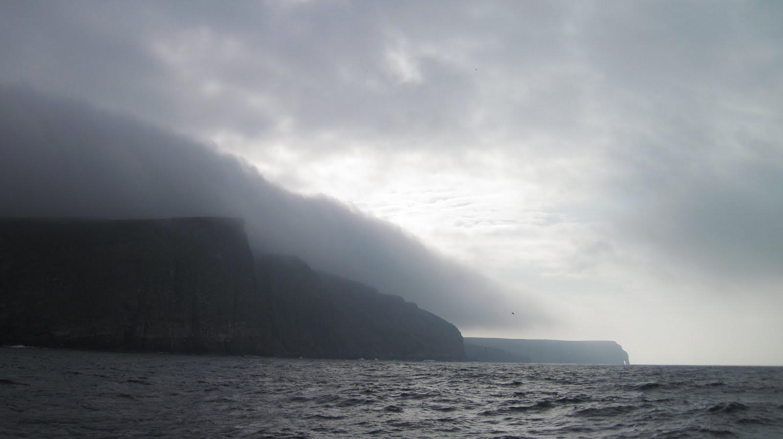
It is a rare sunny warm day in northwest Scotland. The wind built later this afternoon, but no bother as we're snugly tied up at the dock in the lovely village of Lochinver. We arrived in the early afternoon from Kinlochbervie which lies about 30 nautical miles to the north. Our path more or less followed the coastline, giving us peeks of cliffs and spires through the fog. The landscape is quite different from the low lying Orkney Islands (like sailing through eastern Washington fields), the dramatic and fertile Fair Isle, and the more fragile feeling Shetland Islands. Here, on the Scottish west coast, the rock dominates, grey, rounded, and veined with green vegetation with an occasional shock of red sandstone. Not far in the distance inland are higher ridges and old cinder cones, remnants from bygone geological times. It is a stunning place.
At the northwest corner of the Scottish mainland lies Cape Wrath, an impressive cliff plunging into the sea. The name inspires fear and respect, and for good reason. The name, however, derives from an old Norse word (hvarf) meaning 'turning point.' While the current name seems apt, it is comforting to know that it is also simply directional, as in 'turn left here.' Fortunately for us, our experience was closer to the latter meaning; we turned around the cape under mostly sunny skies with low clouds clinging to the cliffs.
We will continue to make our way down the Scottish west coast, around the Isles of Skye and Mull, and possibly with a brief stop in at the Hebrides. Our time here only limited by the need to get to Ireland where we'll meet Joan. We'll try to post photos soon (of which we have many, but none seem to really capture the place). And we'll try to make time to say more about the Shetlands, Fair Isle, and the Orkneys. They are really due some space, but sometimes it is difficult to thoroughly chronicle our travels when there is a rare Scottish wood to walk...
At the northwest corner of the Scottish mainland lies Cape Wrath, an impressive cliff plunging into the sea. The name inspires fear and respect, and for good reason. The name, however, derives from an old Norse word (hvarf) meaning 'turning point.' While the current name seems apt, it is comforting to know that it is also simply directional, as in 'turn left here.' Fortunately for us, our experience was closer to the latter meaning; we turned around the cape under mostly sunny skies with low clouds clinging to the cliffs.
 |
| Cape Wrath, Scotland |
We will continue to make our way down the Scottish west coast, around the Isles of Skye and Mull, and possibly with a brief stop in at the Hebrides. Our time here only limited by the need to get to Ireland where we'll meet Joan. We'll try to post photos soon (of which we have many, but none seem to really capture the place). And we'll try to make time to say more about the Shetlands, Fair Isle, and the Orkneys. They are really due some space, but sometimes it is difficult to thoroughly chronicle our travels when there is a rare Scottish wood to walk...
Sunday, July 17, 2011
Shetlands Islands, Fair Isle, and Orkney Islands
[9 July to 17 July, 2011]
Mousa Island, one of the Shetlands to the south of Lerwick, is home to one of the most intact brochs. We anchored in the small bay and explored this amazing piece of history. The exact use of brochs -- as strongholds for protection or prominent markers of settlement -- are still matters of speculation. The cylindrical structure is impressive, with interior walls forming spiraled pathways around the circumference. The quality of the construction is evidenced by the fact that many are still at least partially standing after 2000 years.
Mainland Shetland appeared on the horizon late in the morning. We were far closer to land than we expected for our first site, due in part to the low-lying terrain and in part to the low-lying clouds. Low as it may be (the highest peak is some 400 meters), the edges are still jagged from millennia of the North Sea pounding against these shores.
 |
| Mainland, Shetland Islands |
Lerwick is snuggled in a well-protected harbor with stone buildings terracing the hillside; a monochrome of grey water, skies, and structures. People have lived in this part of the world for a long time (with archeological sites dating back 5000 years), but one doesn’t get the sense that the living has been easy. Although this was not always the case. Nearly 2000 years ago, the climate here shifted from more Mediterranean-type climes to the cold wet weather now associated with the Shetland Islands, likely a result of significant worldwide volcanic activity. The more favorable climate prior to this change allowed for migration into the Shetlands, as well as Færoe Islands to the northwest and Orkney Islands to the south. Today there is still evidence of these cultures in the form of brochs dating back 2000 years and cairns (or crypts) from 5000 years ago.
 |
| Lerwick, Shetland Islands |
 |
| Lerwick, Shetland Islands |
 |
| Rachel, Karl, and Phil in Lerwick |
 |
| Mousa Broch, with Phil in foreground |
 |
| A view down inside the Mousa Broch |
Forty miles south of the Shetlands lies lonely Fair Isle. The present name is thought to derive from a Norse word for "far island," although no one can doubt that it is also quite fair. We made the passage with a following wind and sun breaks.
 |
| Phil (and the solar panels) catching some much-longed-for sunshine. |
 |
| Sun-inspired scrubbing of the decks |
We had begun to make a practice of long walks, and Fair Isle was a lovely place to walk. It has become a birders' paradise with many migratory birds passing through and nesting in the cliffs and the open grasslands. There is a new observatory that houses researchers and enthusiasts, as well as providing facilities for visiting sailors.
 |
| Lovely Fair Isle |
 |
| Cemetery on Fair Isle, with southern lighthouse in distance (the last UK lighthouse to be automated) |
 |
| Rachel at the helm leaving Fair Isle |
Our stays in each port have been wanting of more time. There is a schedule to keep, so we were off to the Orkney Islands after one night on Fair Isle. We set off for Westray Island in the northwestern Orkneys, considered (at least by Westray-ites) as the "Queen of the Orkneys" especially because of the varied terrain on the island that captures all the Orkneys have to offer. We were indeed surprised to find quite a variety of sites, ranging from a 16th century castle to a tropical beach.
 |
| The Westray Dinghy |
 |
| White sand beach on the north shore of Westray, Orkney Islands |
 |
| Found at the beach |
We made our way south to the island of Rousay, to the northwest of Kirkwall on mainland Orkney Island. Rousay is known for having some of the oldest and most intact archeological sites in the Orkneys. We wended our way from an 18th century castle to a 5000-year-old cairns to 3000-year-old broch. On the way we encountered an in-progress archeological dig. The enthusiasm of the archeologists was infectious as she showed us the picture of civilization they were putting together based on their finds. It is amazing how they can weave together stories of a long-distant past, and striking to experience that archeology is very much alive.
 |
| Rousay Castle, Orkney Islands |
 |
| Entrance to a 5000-year-old cairn (or crypt) |
 |
| "Sørlandet" - a Norwegian tall ship sailing into the Orkneys as part of the Tall Ship Races |
Wednesday, July 6, 2011
Sophia leaves Norway
We set off this afternoon from Kvitsøy, Norway heading for Lerwick in the Shetland Islands. A new journey always brings the excitement of adventure, seeing new landscapes, and meeting new friends. Yet it is also with sadness that we leave Norway.
Our sail around the south of Norway, from Oslo to Kvitsøy (near Stavanger), was spectacular. We found cozy anchorages on little islands and comfortable tie ups in quaint villages. Jim (Rachel's Dad) sailed with us from Oslo to Kristiansand, after which point Karl and I continued on to Tanager where Phil (Karl's Dad) joined us. At every point we were met with a kindness that has become so typical, and continuously remarkable, of our experience in Norway. Here are a few images from the trip from Oslo to Kvitsøy:
 Rachel Sadly lowers the Norwegian Flag for maybe the last time...So, a new adventure begins.

 |
| Jim and Rachel on the dock near Hvasser, Oslofjord, Norway |
 |
| Risør, Norway |
 |
| Hanne and Leif's Cabin at Teistholmen, Kristiansand, Norway |
 |
| Våre near Lidenes (southern most point in Norway) |
 |
| Farsund, Norway at midnight |
We also met our first American sailors since arriving in Norway. Jack and Joselyn Hoopes on Windleblo have been cruising in Scandinavia for a few summers after taking delivery of their Halberg Rassy in Sweden. They graciously loaned us their charts so we could go a wee bit further north before heading across the North Sea. They too are heading to Lerwick where we'll see each other in a couple days.
Subscribe to:
Posts (Atom)